Lunation: 12.11 days Phase: 34.3° Distance: 401013 Km Apparent diameter: 29.80' Illumination: 91.3%
Libration in Latitude: -01°36' Libration in Longitude: +0°25' Position angle: 22.0°
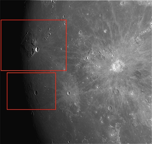
Aristarchus Plateau:
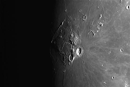
Aristarchus crater is considered the brightest of the large formations on the lunar surface, with an albedo nearly double that of most lunar features. The feature is bright enough to be visible to the naked eye, and displays unusually bright features when viewed through a large telescope. It is also readily identified when most of the lunar surface is illuminated by earthshine. The crater is deeper than the Grand Canyon.
The crater is named after the Greek astronomer Aristarchus of Samos. It is located at the southeastern edge of the Aristarchus plateau, an elevated area that contains a number of volcanic features, such as sinuous rilles. This area is also noted for the large number of reported transient lunar phenomena, as well as recent emissions of radon gas as measured by the Lunar Prospector spacecraft.
Aristarchus is located on the Aristarchus plateau, an elevated rocky rise in the midst of the Oceanus Procellarum, a large expanse of lunar mare. This is a tilted crustal block, about 200 km across, that rises to a maximum elevation of 2 km above the mare in the southeastern section. Aristarchus is just to the east of the crater Herodotus and the Vallis Schröteri, and south of a system of narrow sinuous rilles named Rimae Aristarchus.
Aristarchus is bright because it is a relatively young formation, approximately 450 million years old, and the solar wind has not yet had time to darken the excavated material by the process of space weathering. The impact occurred following the creation of the ray crater Copernicus, but before the appearance of Tycho. Due to its prominent rays, Aristarchus is mapped as part of the Copernican System.
The brightest feature of this crater is the steep central peak. Sections of the interior floor appear relatively level, but Lunar Orbiter photographs reveal the surface is covered in many small hills, streaky gouges, and some minor fractures. The crater has a terraced outer wall, roughly polygonal in shape, and covered in a bright blanket of ejecta. These spread out into bright rays to the south and south-east, suggesting that Aristarchus was most likely formed by an oblique impact from the northeast, and their composition includes material from both the Aristarchus plateau and the lunar mare
In November 2011, the Lunar Reconnaissance Orbiter passed over the crater, which spans almost 40 kilometers and sinks more than 3.5 kilometers deep. "The Aristarchus plateau is one of the most geologically diverse places on the moon: a mysterious raised flat plateau, a giant rille carved by enormous outpourings of lava, fields of explosive volcanic ash, and all surrounded by massive flood basalts," said Mark Robinson, principal investigator of the Lunar Reconnaissance Orbiter Camera at Arizona State University. NASA released photos of the crater on December 25, 2011.
In 1911, Professor Robert W. Wood used ultraviolet photography to take images of the crater area. He discovered the plateau had an anomalous appearance in the ultraviolet, and an area to the north appeared to give indications of a sulfur deposit. This colorful area is sometimes referred to as "Wood's Spot", an alternative name for the Aristarchus plateau.
Spectra taken of this crater during the Clementine mission were used to perform mineral mapping. The data indicated that the central peak is a type of rock called anorthosite, which is a slow-cooling form of igneous rock composed of plagioclase feldspar. By contrast the outer wall is troctolite, a rock composed of equal parts plagioclase and olivine.
The Aristarchus region was part of a Hubble Space Telescope study in 2005 that was investigating the presence of oxygen-rich glassy soils in the form of the mineral ilmenite. Baseline measurements were made of the Apollo 15 and Apollo 17 landing sites, where the chemistry is known, and these were compared to Aristarchus. The Hubble Advanced Camera for Surveys was used to photograph the crater in visual and ultraviolet light. The crater was determined to have especially rich concentrations of ilmenite, a titanium oxide mineral that could potentially be used in the future by a lunar settlement for extracting oxygen.
The region of the Aristarchus plateau has been the site of many reported transient lunar phenomena, with a total of 122 such reports by 2007; the highest recorded for any lunar feature. Such events include temporary obscurations and colorations of the surface, and catalogues of these show that more than one-third of the most reliable spottings come from this locale. In 1971 when Apollo 15 passed 110 kilometers above the Aristarchus plateau, a significant rise in alpha particles was detected. These particles are believed to be caused by the decay of radon-222, a radioactive gas with a half-life of only 3.8 days. The Lunar Prospector mission later confirmed radon-222 emissions from this crater. These observations could be explained by either the slow and visually imperceptible diffusion of gas to the surface, or by discrete explosive events.
One of the oldest reports of transient lunar phenomena in Aristarchus is an observation made by Heinrich Wilhelm Matthias Olbers on 5 February 1821. Contemporary Henry Kater publicly believed that this and other events were due to volcanic activity on the Moon, a belief not so confidently shared by Olbers, who believed it explainable in a manner "more consistent with what we know of the physical construction of the moon [sic]."
Source: Wikipedia
Marius Hills: 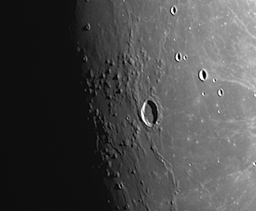
The Marius Hills are a set of volcanic domes located in Oceanus Procellarum on Earth's Moon. The domes are thought to have formed from lavas more viscous than those that formed lunar mares. These domes average approximately 200500 m in height. The Marius Hills take their name from the nearby 41 km diameter crater Marius. These hills represent the highest concentration of volcanic features on the Moon.
An abundance of domes, cones, and volcanic rilles and channels is characteristic of the Marius Hills. The Lunar Reconnaissance Orbiter photographed a pit that could be a skylight in a lava tube, indicating that part of its roof has collapsed, as often happens after lava tubes cease to be active.
Data from the Lunar Reconnaissance Orbiter has been used to identify two different varieties of domes among the Marius Hills: (1) large, irregularly shaped domes and (2) smaller domes with steep sides and diameters of about 12 km. Another feature, possibly pyroclastic, or primarily volcanic in composition, has a roughly circular shape and steep sides. Bright, high albedo boulders have been shown to be characteristic of lava flows in the Marius Hills. This suggests blocky lava with a high silica content formed these features. This hypothesis, however, is not supported by data obtained from the Clementine lunar orbiter. Analysis of lower albedo, or less reflective boulders suggest that many domes in the area may contain two layers of material: (1) an upper layer of thin, dark material covering (2) a layer of thick, bright material.
The hole, first discovered by the Japanese SELenological and ENgineering Explorer (SELENE) and then later imaged by the Lunar Reconnaissance Orbiter has been the subject of much research and speculation. There is a possibility that this feature could be a skylight in a lava tube. The depth of this hole is estimated to be between 80 and 88 m and its width is estimated to be several hundreds of meters. Additional radar echo patterns suggesting intact lava tubes have been found at several other locations around the Marius Hills, which correspond to areas of mass deficit in the GRAIL data.
The Marius Hills region was at one time considered a possible landing site for a lunar landing mission during the American Apollo program (eventually becoming the alternative site for Apollo 15), with the possibility of gaining insight about the volcanic history of the Moon from domes in the area.
A site in the northern Marius Hills, located in the center of a five-kilometer circle in a shallow valley between four domes near a small sinuous depression, was one of nine potential Apollo landing sites studied in-depth as part of a 1968 Bellcom report describing the geology of those nine locations and potential mission plans. This site in particular, the Bellcom study suggested, could have offered the opportunity for up-close examination of planetary ridges similar to those located at the bottoms of Earth's oceans and sampling of a variety of material from the Moon's interior churned up during the area's highly active volcanic past. The Bellcom study referenced an earlier 1968 study, prepared by the United States Geological Survey, that outlined a detailed mission plan for the proposed site. This plan included four EVAs using a Lunar Roving Vehicle and Lunar Flying Units for increased mobility in sampling the various features in the site radius.
The probable lava tube could provide radiation shielding for a future underground lunar colony. However, it is unclear whether the tube is open or accessible. Two other lunar sites have been found by remote sensing, including on the far side's Mare Ingenii. An even larger, intact but buried lava tube estimated to be 1.7 km in length and 120m wide was detected by the Chandrayaan-1 orbiter.
Source: Wikipedia |