Mouse Over Image / Mover el ratón sobre la imagen
 
Mare Serenitatis & Traquilitatis, 5.9 days 33.6%  
Moon

Wide area from Posidonius to Mare Tranquilitatis
 
 
Mare Serenitatis is a lunar mare located to the east of Mare Imbrium on the Moon. Its diameter is 674 km (419 mi).

Mare Serenitatis is located within the Serenitatis basin, which is of the Nectarian epoch. The material surrounding the mare is of the Lower Imbrian epoch, while the mare material is of the Upper Imbrian epoch. The mare basalt covers a majority of the basin and overflows into Lacus Somniorum to the northeast. The most noticeable feature is the crater Posidonius on the northeast rim of the mare. The ring feature to the west of the mare is indistinct, except for Montes Haemus. Mare Serenitatis connects with Mare Tranquillitatis to the southeast and borders Mare Vaporum to the southwest. Mare Serenitatis is an example of a mascon, an anomalous gravitational region on the moon.

A mass concentration (mascon), or gravitational high, was identified in the center of Mare Serenitatis from Doppler tracking of the five Lunar Orbiter spacecraft in 1968. The mascon was confirmed and mapped at higher resolution with later orbiters such as Lunar Prospector and GRAIL.

Like most of the other maria on the Moon, Mare Serenitatis was named by Giovanni Riccioli, whose 1651 nomenclature system has become standardized. Previously, William Gilbert had cited it as within the Regio Magna Occidentalis ("Large Western Region") in his map of c.1600. Pierre Gassendi had included it as part of the 'Homuncio' ('little man'), referring to a small humanoid figure that he could see among the maria; Gassendi also referred to it as 'Thersite' after Thersites, the ugliest warrior in the Trojan War. Michael Van Langren had labelled it the Mare Eugenianum ("Eugenia's Sea") in his 1645 map, in honour of Isabella Clara Eugenia, queen of the Spanish Netherlands. And Johannes Hevelius included it within Pontus Euxinus (after the classical name for the Black Sea) in his 1647 map.

Mare Tranquillitatis is a lunar mare that sits within the Tranquillitatis basin on the Moon. It is the first location on another world to be visited by humans.

The mare material within the basin consists of basalt formed in the intermediate to young age group of the Upper Imbrian epoch. The surrounding mountains are thought to be of the Lower Imbrian epoch, but the actual basin is probably Pre-Nectarian. The basin has irregular margins and lacks a defined multiple-ringed structure. The irregular topography in and near this basin results from the intersection of the Tranquillitatis, Nectaris, Crisium, Fecunditatis, and Serenitatis basins with two throughgoing rings of the Procellarum basin. Palus Somni, on the northeastern rim of the mare, is filled with the basalt that spilled over from Tranquillitatis.

This mare has a slight bluish tint relative to the rest of the Moon and stands out quite well when color is processed and extracted from multiple photographs. The color is likely due to higher metal content in the basaltic soil or rocks.

Unlike many other maria, there is no mass concentration (mascon), or gravitational high, in the center of Mare Tranquillitatis. Mascons were identified in the center of other maria (such as Serenitatis or Imbrium) from Doppler tracking of the five Lunar Orbiter spacecraft in 1968.[4] The gravity field was mapped at higher resolution with later orbiters such as Lunar Prospector and GRAIL, which unveiled an irregular pattern.

Posidonius is a lunar impact crater that is located on the north-eastern edge of Mare Serenitatis, to the south of Lacus Somniorum. It was named after ancient Greek philosopher and geographer Posidonius of Apamea. The crater Chacornac is attached to the southeast rim, and to the north is Daniell.

The rim of Posidonius is shallow and obscured, especially on the western edge, and the interior has been overlain by a lava flow in the past. The crater ramparts can still be observed to the south and east of the crater rim, and to a lesser degree to the north.

There is a smaller, semi-circular rim of a concentric, flooded crater within the main rim, offset towards the eastern edge. There is no central peak, but the floor is hilly and laced with a rille system named the Rimae Posidonius. The floor is also slightly bulged due to the past lava uplift, which also likely produced the complex of rilles. The northeast rim is interrupted by the smaller crater Posidonius B. Within the crater rim, offset just to the west of center is another smaller crater Posidonius A.

On the Mare Serenitatis surface near Posidonius is a notable system of wrinkle ridges that parallel the nearby shore. These are designated the Dorsa Smirnov. At the peak of these ridges is a small craterlet (Posidonius Y) with a diameter of 2 km. This craterlet is surrounded by a patch of high-albedo material, and is an example of a lunar bright spot. This peak was formerly designated Posidonius Gamma (γ).

Posidonius Gamma was first observed by the lunar cartographer Julius Schmidt in 1867, who noted the similarity to the bright patch surrounding the crater Linné.

Le Monnier is the remnant of a lunar impact crater that has been partly inundated by lava flows. It was named after French astronomer Pierre Charles Le Monnier. It is located on the eastern edge of Mare Serenitatis, and the western part of the rim is missing so that it now forms a large bay. To the north is the crater Chacornac.

The interior of this formation is relatively flat and smooth, with no significant craterlets to mark the surface. The outer rim is battered, worn, and notched with past impacts. Only slight wrinkle ridges now mark where the western rim once lay.

The landing site of the Luna 21 space probe is located near the southern rim of Le Monnier. Lunokhod 2, a robotic roving vehicle deposited on the surface by Luna 21, covered a distance of 37 kilometers across the crater floor. It also surveyed the southern edge of the crater rim.

(Wikipedia)

 
Spanish 
El Mar de la Serenidad es un mar lunar, ubicado al este del Mare Imbrium y al sur del Mare Frigoris.​

Se encuentra en la cuenca Serenitatis, que data del periodo Nectárico.​ El material que rodea al Mare es del periodo Ímbrico Inferior, mientras que el material de su interior es del Ímbrico Superior.1​ La cubierta basáltica, que cubre casi todo su interior, e incluso rellena el Lacus Somniorum,1​ refleja un largo periodo de actividad volcánica, aunque la conformación de la capa basáltica indica la existencia de material volcánico anterior al Mare.3

Su característica más destacable es el cráter Posidonius, en el borde noreste del mar. La pared este del mare es indistinguible, excepto por los Montes Haemus. Se conecta con el Mare Tranquillitatis en el sureste, y limita con el Mare Vaporum hacia el suroeste. Mare Serenitatis es un ejemplo de mascon (anomalía gravitatoria).

Las naves Luna 21 y Apolo 17 alunizaron en la zona este del Mare, en las proximidades de los Montes Taurus.

El mar de la Tranquilidad o Mare Tranquillitatis es un extenso mar lunar donde el 20 de julio de 1969 descendió el módulo lunar de la nave Apolo 11, con los astronautas Edwin Buzz Aldrin y Neil Armstrong, siendo este último la primera persona en pisar la superficie lunar, mientras que Michael Collins se quedó orbitando la Luna en el módulo de mando.

El primer astrónomo en asignar un nombre a este mar lunar fue Michael van Langren, flamenco al servicio de Felipe IV de España, en su Lumina Austriaca Philippica de 1645. Van Langren lo llamó "Mare Belgicum", uno de los nombres clásicos del Mar del Norte. Johannes Hevelius, en su mapa lunar de 1647, lo llamó "Pontus Euxinus", nombre clásico del Mar Negro.

El nombre de "Mare Tranquillitatis" fue otorgado en 1651 por los astrónomos jesuitas Francesco Grimaldi y Giovanni Battista Riccioli en su Almagestum novum,4​5​ y es el que ha perdurado hasta hoy.

El material de mare dentro de la cuenca consiste en basalto formado en el grupo de edad intermedia a joven de la época del Alto Imbrian. Se cree que las montañas circundantes pertenecen a la época del Imbrio Inferior, pero la cuenca real es probablemente prenectariana. La cuenca tiene márgenes irregulares y carece de una estructura definida de múltiples anillos. La topografía irregular en y cerca de esta cuenca resulta de la intersección de las cuencas Tranquillitatis, Nectaris, Crisium, Fecunditatis y Serenitatis con dos anillos de la cuenca Procellarum. Palus Somni, en el borde nororiental del mar, está lleno del basalto que se derramó de Tranquillitatis. 

Este mar tiene un ligero tinte azulado en relación con el resto de la Luna y se destaca bastante bien cuando se procesa y extrae el color de múltiples fotografías. Es probable que el color se deba a un mayor contenido de metal en el suelo o las rocas basálticas.

A diferencia de muchos otros maria, no hay concentración de masa (mascon), o alta gravitacional, en el centro de Mare Tranquillitatis. Se identificaron mascons en el centro de otros mares (como Serenitatis o Imbrium) a partir del seguimiento Doppler de las cinco naves espaciales Lunar Orbiter en 1968 El campo de gravedad se cartografió a mayor resolución con orbitadores posteriores como Lunar Prospector y GRAIL, que revelaron un patrón irregular.

Le Monnier es el remanente de un cráter de impacto lunar que ha sido parcialmente inundado por flujos de lava. Se encuentra en el borde oriental del Mare Serenitatis. La parte occidental de su borde ha desaparecido, formando una gran bahía. Al norte se halla el cráter Chacornac.

El interior de esta formación es relativamente plano y liso, sin accidentes significativos que marquen su superficie. El borde exterior aparece golpeado, desgastado y lleno de muescas como resultado de impactos pasados. Solamente unas pequeñas crestas indican el lugar donde estuvo situado el sector oeste del brocal.

El lugar de alunizaje de la sonda espacial Luna 21 se encuentra cerca del borde sur de Le Monnier. El Lunojod 2, un vehículo robotizado depositado en la superficie por el Luna 21, cubrió una distancia de 37 kilómetros a través del suelo del cráter, examinando también su borde sur.

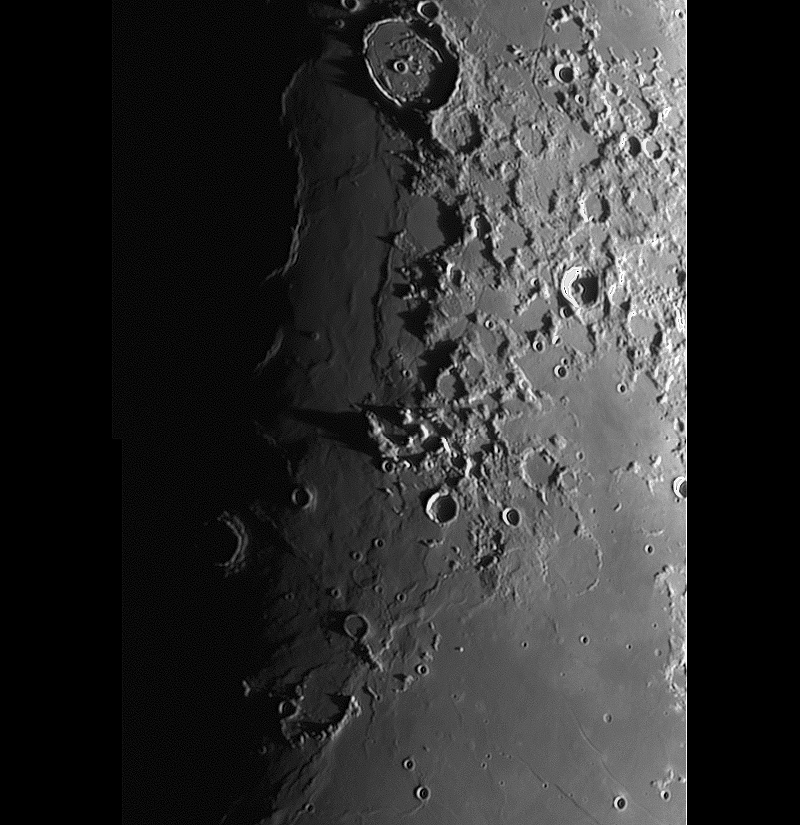
Posidonius es un cráter de impacto lunar que está situado en el extremo nororiental del Mare Serenitatis, al sur del Lacus Somniorum. El cráter Chacornac está unido al borde sureste, y al norte se halla el cráter Daniell.

El borde de Posidonius es oscuro y poco profundo, especialmente en el borde occidental. Su interior ha sido cubierto por flujos de lava en el pasado. Los taludes del cráter todavía se pueden observar en el sur y en el este del borde del cráter, y en menor grado en el norte.

Presenta un borde semicircular interior, perteneciente a un cráter concéntrico, inundado dentro del borde principal, desplazado hacia el borde oriental. No posee ningún pico central, pero el suelo es montañoso y posee un sistema de grietas denominado Rimae Posidonius. La planta también está ligeramente abombada debido a una antigua efusión de lava, que también es probable que produjera el complejo de crestas. El extremo noreste es interrumpido por el cráter más pequeño Posidonius B. Dentro del borde del cráter, que se compensa justo al oeste del centro, aparece otro cráter más pequeño, Posidonius A.

En la superficie del Mar de la Serenidad, cerca de Posidonius, se localiza un sistema notable de dorsa que son paralelos a la costa cercana. Estos se designan como Dorsa Smirnov. La cima de estas crestas muestra un pequeño cráter con un diámetro de unos 2 km. Este cratercillo está rodeado por una zona de material de alto albedo, y es un ejemplo de un punto brillante lunar. Esta elevación fue designada anteriormente como Posidonius Gamma (γ).

Posidonius Gamma fue observado por primera vez por el cartógrafo lunar Julius Schmidt en 1857, quien señaló la similitud con la zona brillante que rodea el cráter Linné.

(Wikipedia)
 
 
Technical details:  
Location:  
Valdemorillo - Spain
Date:  
06/02/2022 (dd/mm/yyyy)
Conditions:  
Normal
Temperature:  
ºC
Humidity:  
 
Telescope:  
Vixen 102M f/9.8
Reducer/corrector:  
Celestron Ultima SV Barlow 2x
Filter:  
Astronomik R Type-II
Mount:  
Orion Atlas EQG
Camera:  
DMK 23U618
Exposure:  
Guiding tube:  
No guiding
Guiding camera:  
No guide camera
Guiding software:  
No guide software
 
Procesing:  
Autostakert + Registax + PixInsight  
Notes:  


All Contents Copyright by Jaime Fernández and Copyright of their respectives owners. Text mainly extracted from Wikipedia.
All Jaime Fernandez propietary contents freely available for non-profit purposes,
otherwise I beg you for a fair contribution to NGO Medicos Sin Fronteras proportional to the profit obtained.

Este sitio web usa cookies para su funcionamiento. No utiliza cookies publicitarias ni de personalización.
Al navegar por esta web aceptas el uso de estas cookies y que tus datos de navegación sean anónimamente recopilados para conteo estadístico y control de acceso
(IP origen, fecha y hora, página visitada y términos de búsqueda usados).