Mouse Over Image / Mover el ratón sobre la imagen
 
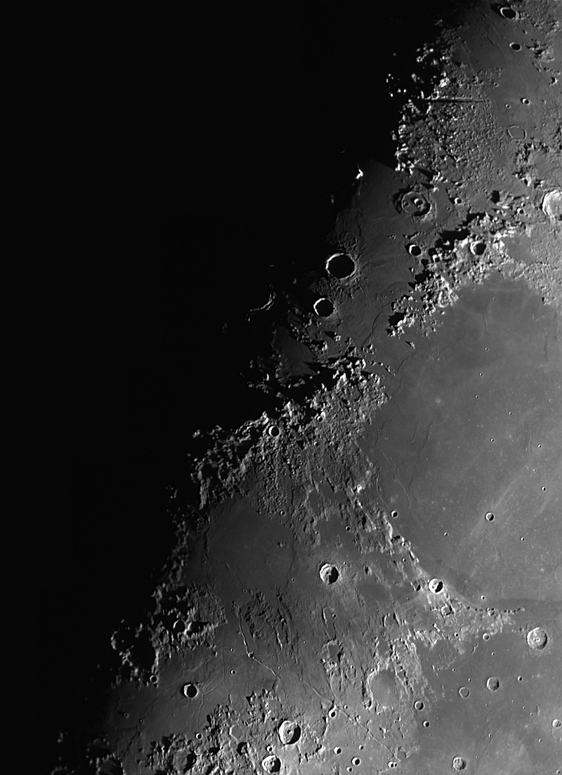
Alpes, Caucasus & Apenninus areas, 8.2 days 58.2%  
Moon

10 image mosaic of the moon covering Alpes, Caucasus and Apenninus Mons Areas
 
 
Montes Alpes is a mountain range in the northern part of the Moon's near side. It was named after the Alps in Europe; the name was confirmed by the International Astronomical Union in 1935.

This range forms the northeastern border of the Mare Imbrium lunar mare. To the west of the range is the level and nearly featureless mare, while on the eastern face is a more rugged continental area with a higher albedo. The range begins about one crater diameter northwest of the crater Cassini, at the Promontorium Agassiz, then stretches about 280 kilometres to the northwest and continues in intermittent fashion and the mountains proper end shy of one crater length from the eastern rim of the dark-floored crater Plato. The system of rilles named Rimae Plato may be found in between the eastern edge of Plato and the western edge of the Alpes mountains. The peaks of the Alpes range in height from 1,800m to 2,400m.

The Alpes range was part of the middle ring of the multi-ringed Imbrium Basin. The other mountain ranges around the Imbrium Basin (Montes Caucasus, Montes Apenninus, and Montes Carpatus) were part of the outer ring. The Alpes, being part of the middle ring, thus have a shorter radius to the center of Imbrium than the other ranges of the basin.

The northwestern third of the range is separated from the remainder of the mountains by the Vallis Alpes, a wide rift valley that extends from a narrow cleft in the Montes Alpes to the northeast, reaching the edge of the Mare Frigoris. The total length of this formation is about 166 km, and it reaches a maximum width of 10 km. 

About one-third the length of the range from the southeast is Mons Blanc, a peak rising to a height of 3.6 km. This compares to a typical height of peaks in this range of 1.8 to 2.4 km. Midway between Mons Blanc and Promontorium Agassiz is Promontorium Deville. To the southwest of Promontorium Agassiz is the isolated Mons Piton, a peak rising to a height of 2.3 km. Blanc, Piton, and the Montes Teneriffe make up part of the inner ring of the Imbrium Basin.

Montes Caucasus is a rugged range of mountains in the northeastern part of the Moon. It begins at a gap of level surface that joins the Mare Imbrium to the west with the Mare Serenitatis to the east, and extends in an irregular band to the north-northeast to the western side of the prominent crater Eudoxus. The range forms the northwestern boundary of the Mare Serenitatis. It forms a continuation of the Montes Apenninus range to the southwest.

There are several breaks in the range where nearby lunar mare has intruded into the formation, particularly near the southern tip. Embedded within the eastern flank of the range is the crater Calippus. Along the eastern flank to the south of Eudoxus is the remnants of the crater Alexander.

The range was named after the Caucasus Mountains on the Earth by the German selenographer Johann H. Mädler. However none of the peaks in this range has been assigned individual names, at least officially.

Montes Apenninus are a rugged mountain range on the northern part of the Moon's near side. They are named after the Apennine Mountains in Italy. With their formation dating back about 3.9 billion years, Montes Apenninus are still relatively young.

This range forms the southeastern border of the large Mare Imbrium lunar mare and the northwestern border of the Terra Nivium highland region. It begins just to the west of the prominent crater Eratosthenes, which abuts against the southern face of the range. To the west of these mountains is a narrow gap where Mare Imbrium in the north joins Mare Insularum to the south. Further to the west are the Montes Carpatus mountains.

From Eratosthenes, the mountains form an arcing chain that gradually bends from east to northeast, ending at Promontorium Fresnel at about latitude 29.5° N. Here is another gap where the Mare Imbrium to the west joins the Mare Serenitatis to the east. At the north end of this gap lie the Montes Caucasus.

Mons Hadley Delta and Mons Hadley are perhaps most famous for forming the valley where the Apollo 15 mission made its landing. This landing was considered one of the most scientifically successful missions of the Apollo program and started the last three J-Series missions that included the lunar rover and 3-day stays. Apollo 15 explored smaller peak Mons Hadley Delta (δ) and Rima Hadley rille. This was perhaps the most geologically diverse landing site of the program.

Much of this range forms a sharp, rugged rise at the edge of the Mare Imbrium, with a wide expanse of foothills on the far (southeastern) face. There are, however, some rugged foothills on the northwestern side along the section of the range to the southeast of Archimedes. The total length of the range is about 600 km (370 mi), with some of the peaks rising as high as 5 km (3.1 mi).

Spanish
Los Montes Alpes son una cadena montañosa de la luna, situada entre el Mare Imbrium y el Mare Frigoris. El nombre fue puesto por el astrónomo Johannes Hevelius en referencia a la cordillera de los Alpes terrestres.

La cordillera tiene una longitud de 281 km y una anchura máxima de unos 80 km, que alberga varios picos con una altura media de 2400 m. Viene delimitada en sus extremos por el cráter Platón en el noroeste y el cráter Cassini en el sureste. La cordillera se encuentra dividida en dos mitades por el Vallis Alpes (Valle de los Alpes), de 130 km de longitud y 11 km de anchura, bordeada por gargantas de 1000 m de altitud.

El pico más alto de la cordillera es el Mons Blanc con 25 km de anchura y 3600 m de altitud. En el extremo sureste de la cordillera se encuentran el Promontorio Deville, con una anchura de 16.56 km y una altura de 1300 m, y el Promontorio Agassiz, con una anchura de 18.84 km y una altitud de 2470 m.1​ Los promontorios (promontorium) son el equivalente lunar de un cabo terrestre.


Los Montes Caucasus (Montes Cáucaso) son una cadena montañosa de la cara visible de la Luna, situada entre el Mare Imbrium y el Mare Serenitatis. El nombre procede de las Montañas del Cáucaso terrestres.

La cordillera tiene una longitud de 443 km y una anchura máxima de unos 100 km, cuyas cumbres, que culminan a 3500 m, están separadas por profundos valles. En su zona central se encuentra incrustado el cráter Calippus y los restos del cráter Alexander, y más hacia el norte los destacados cráteres Eudoxus y Aristóteles.

Al suroeste de la cordillera se encuentran los Montes Apenninus y los Montes Carpatus. 

Los Montes Apenninus (Montes Apeninos) son una cordillera situada en la parte norte de la cara visible de la Luna, bautizada en alusión a los Montes Apeninos en Italia. La cadena montañosa, que es la más importante del satélite, se encuentra al sur de los Montes Alpes y tiene una longitud de casi 600 km,​ y su cumbre más alta es el Mons Huygens, con 5500 m de altitud.

Los Montes Apenninus forman el límite suroriental del Mare Imbrium y el noroccidental de la región de la meseta de Terra Nivium, y están situados inmediatamente al este del cráter Eratosthenes. Al oeste de los Montes Apenninus se encuentra una estrecha abertura que une el Mare Imbrium con el Mare Insularum, al sur. Más al oeste, se encuentran los Montes Carpatus.

Desde el cráter Eratosthenes, los Apeninos lunares se observan en forma de una cadena que gradualmente se arquea de este a noreste, terminando en el Promontorium Fresnel. Aquí hay otra abertura, donde el Mare Imbrium, al oeste, se une al Mare Serenitatis, al este. En la parte norte de esta brecha se encuentran los Montes Caucasus.

El nombre de Montes Apeninos se lo dio el astrónomo polaco Johannes Hevelius (1611-1687), siendo aprobado por la Unión Astronómica Internacional en 1961.

Los Montes Apenninus junto con los Montes Carpatus y los Montes Caucasus constituyen algunos de los fragmentos supervivientes del anillo exterior, de un conjunto original de tres, formados por el impacto que causó la formación de la cuenca del Mare Imbrium hace unos 3850 millones de años.3​


Technical details:  
Location:  
Valdemorillo - Spain
Date:  
11/12/2021 (dd/mm/yyyy)
Conditions:  
Bad
Temperature:  
ºC
Humidity:  
 
Telescope:  
Vixen 102M f/9.8
Reducer/corrector:  
Celestron Ultima SV Barlow 2x
Filter:  
Astronomik G Type-II
Mount:  
Orion Atlas EQG
Camera:  
DMK 23U618
Exposure:  
10 images mosaic, 1500 frames @30fps each
Guiding tube:  
No guiding
Guiding camera:  
No guide camera
Guiding software:  
No guide software
 
Procesing:  
AutoStakkert_64_3.0.14 + Registax 6 + PixInsight 1.8.8-7  
Notes:  


All Contents Copyright by Jaime Fernández and Copyright of their respectives owners. Text mainly extracted from Wikipedia.
All Jaime Fernandez propietary contents freely available for non-profit purposes,
otherwise I beg you for a fair contribution to NGO Medicos Sin Fronteras proportional to the profit obtained.

Este sitio web usa cookies para su funcionamiento. No utiliza cookies publicitarias ni de personalización.
Al navegar por esta web aceptas el uso de estas cookies y que tus datos de navegación sean anónimamente recopilados para conteo estadístico y control de acceso
(IP origen, fecha y hora, página visitada y términos de búsqueda usados).