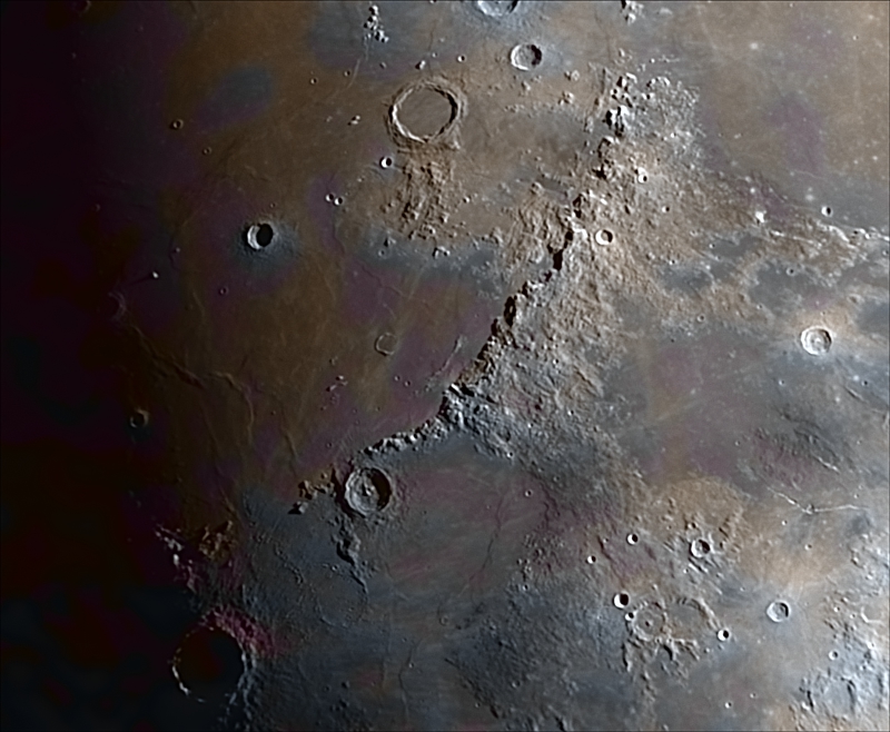
Apenninus area, enhanced color, 9.4 days 65.6%  
Moon

Apenninus Mons area, enhanced color
 
 
Apenninus Mons are a rugged mountain range on the northern part of the Moon's near side. They are named after the Apennine Mountains in Italy. With their formation dating back about 3.9 billion years, Montes Apenninus are still relatively young.

This range forms the southeastern border of the large Mare Imbrium lunar mare and the northwestern border of the Terra Nivium highland region. It begins just to the west of the prominent crater Eratosthenes, which abuts against the southern face of the range. To the west of these mountains is a narrow gap where Mare Imbrium in the north joins Mare Insularum to the south. Further to the west are the Montes Carpatus mountains.

From Eratosthenes, the mountains form an arcing chain that gradually bends from east to northeast, ending at Promontorium Fresnel at about latitude 29.5° N. Here is another gap where the Mare Imbrium to the west joins the Mare Serenitatis to the east. At the north end of this gap lie the Montes Caucasus.

Mons Hadley Delta and Mons Hadley are perhaps most famous for forming the valley where the Apollo 15 mission made its landing. This landing was considered one of the most scientifically successful missions of the Apollo program and started the last three J-Series missions that included the lunar rover and 3-day stays. Apollo 15 explored smaller peak Mons Hadley Delta (δ) and Rima Hadley rille. This was perhaps the most geologically diverse landing site of the program.

Much of this range forms a sharp, rugged rise at the edge of the Mare Imbrium, with a wide expanse of foothills on the far (southeastern) face. There are, however, some rugged foothills on the northwestern side along the section of the range to the southeast of Archimedes. The total length of the range is about 600 km (370 mi), with some of the peaks rising as high as 5 km (3.1 mi).

Despite appearances, the surface of the Moon has color and it is possible to capture it with a camera. Each color is due to the large-scale presence of some type of mineral in the lunar crust, from basalts and iron oxides to titanium.

The color tones are very subtle, but real (it is not synthetic color), so during image processing the color saturation must be increased to make it visible.

The technique used here uses one color images obtained with a DSLR camera and one image from monochrome camera with green filter used as luminance.

Spanish
Los Montes Apenninus (Montes Apeninos) son una cordillera situada en la parte norte de la cara visible de la Luna, bautizada en alusión a los Montes Apeninos en Italia. La cadena montañosa, que es la más importante del satélite, se encuentra al sur de los Montes Alpes y tiene una longitud de casi 600 km,​ y su cumbre más alta es el Mons Huygens, con 5500 m de altitud.

Los Montes Apenninus forman el límite suroriental del Mare Imbrium y el noroccidental de la región de la meseta de Terra Nivium, y están situados inmediatamente al este del cráter Eratosthenes. Al oeste de los Montes Apenninus se encuentra una estrecha abertura que une el Mare Imbrium con el Mare Insularum, al sur. Más al oeste, se encuentran los Montes Carpatus.

Desde el cráter Eratosthenes, los Apeninos lunares se observan en forma de una cadena que gradualmente se arquea de este a noreste, terminando en el Promontorium Fresnel. Aquí hay otra abertura, donde el Mare Imbrium, al oeste, se une al Mare Serenitatis, al este. En la parte norte de esta brecha se encuentran los Montes Caucasus.

El nombre de Montes Apeninos se lo dio el astrónomo polaco Johannes Hevelius (1611-1687), siendo aprobado por la Unión Astronómica Internacional en 1961.

Los Montes Apenninus junto con los Montes Carpatus y los Montes Caucasus constituyen algunos de los fragmentos supervivientes del anillo exterior, de un conjunto original de tres, formados por el impacto que causó la formación de la cuenca del Mare Imbrium hace unos 3850 millones de años.3​

A pesar de las apariencias, la superficie de la Luna tiene color y es posible capturarlo con una cámara. Cada color se debe a la presencia a gran escala de algún tipo de mineral de la corteza lunar, desde basaltos y óxidos de hierro hasta titanio.

Los tonos de color son muy sutiles, pero reales (no es color sintético), por lo que durante el procesado de la imagen se debe aumentar la saturación de color para hacerlo visible. 

La técncia aquí empleada utiliza una imagen obtenida con una cámara color DSLR y una imagen procedente de una cámara monocromo con filtro verde como luminancia.
 
 
Technical details:  
Location:  
Valdemorillo - Spain
Date:  
15/06/2024 (dd/mm/yyyy)
Conditions:  
Average
Temperature:  
ºC
Humidity:  
 
Telescope:  
Vixen 102M f/9.8
Reducer/corrector:  
No reducer
Filter:  
Astronomik G Type-II 2"
Mount:  
Orion Atlas EQG
Camera:  
ZWO ASI178MM
Exposure:  
2000 frames @17fps
Guiding tube:  
No guiding
Guiding camera:  
No guide camera
Guiding software:  
No guide software
 
Procesing:  
AutoStakkert_64 v4 + Registax 6 + PixInsight 1.8  
Notes:  


All Contents Copyright by Jaime Fernández and Copyright of their respectives owners. Text mainly extracted from Wikipedia.
All Jaime Fernandez propietary contents freely available for non-profit purposes,
otherwise I beg you for a fair contribution to NGO Medicos Sin Fronteras proportional to the profit obtained.

Este sitio web usa cookies para su funcionamiento. No utiliza cookies publicitarias ni de personalización.
Al navegar por esta web aceptas el uso de estas cookies y que tus datos de navegación sean anónimamente recopilados para conteo estadístico y control de acceso
(IP origen, fecha y hora, página visitada y términos de búsqueda usados).