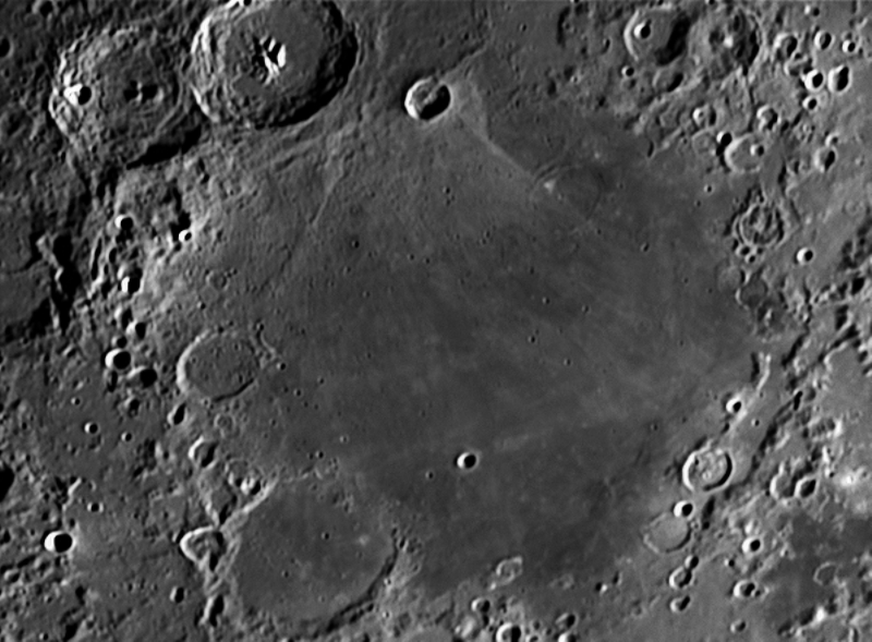
Mare Nectaris (Latin nectaris, the "Sea of Nectar") is a small lunar mare or sea (a volcanic lava plain noticeably darker than the rest of the Moon's surface) located south of Mare Tranquillitatis southwest of Mare Fecunditatis, on the near side of the moon. Montes Pyrenaeus borders the mare to the east and Sinus Asperitatis fuses to its northwestern edge. It is 84,000 square kilometers in size.
Several large craters are situated at the borders of Mare Nectaris. The biggest one is lava-filled Fracastorius (124 km), which fuses with southern coast of the Sea. A prominent trio of 100-km craters Theophilus, Cyrillus and Catharina is located near northwestern coast. Other notable feature is a "ghost crater" Daguerre, almost entirely covered with lava, in the northern part of Mare Nectaris.
Mare Nectaris is located in the central part of 860-km-diameter impact basin, which was formed 3.8–3.9 billions year ago. This event marks the beginning of Nectarian period of the lunar geologic timescale. The best-preserved part of the rim of this basin is called Rupes Altai, in the southwest part of the basin.
Lava filling of Mare Nectaris is younger than the basin itself. The mare material is approximately 1000m in depth, and mainly of the Nectarian period and the Lower Imbrian epoch, with the mare material of the Upper Imbrian epoch. The crater Theophilus on the northeastern side of the mare is of the Eratosthenian period. Thus, the crater is younger than the mare to its southeast. Enough subsidence has occurred to open a few arcuate grabens on the western margin of the mare.
A mass concentration (mascon), or gravitational high, was identified in the center of Mare Nectaris from Doppler tracking of the five Lunar Orbiter spacecraft in 1968. The mascon was confirmed and mapped at higher resolution with later orbiters such as Lunar Prospector and GRAIL.
Mare Nectaris es un mar lunar situado en la cara visible de la Luna. Data de la Era Nectárica (3.920 /3.850 millones de años), a la cual da nombre. Tiene una forma aproximadamente circular, con 350 km de diámetro y una superficie de unos 100.000 km².
El Mare Nectaris, que ocupa la parte central de una amplia cuenca de impacto inundada por lavas, se extiende entre los cráteres Mädler y Gaudibert, al norte, y Fracastorius, al sur, y entre los Montes Pirineos lunares, al este, y una zona accidentada que ocupa el espacio entre los cráteres Theophilus y Beaumont, al oeste.
La parte central del Mare Nectaris es notablemente llana y carece de cráteres importantes, estimándose que en ella, la capa de lava solidificada es de solo un kilómetro de espesor.
La cuenca original que contiene al Mare Nectaris, es de unos 900 km de diámetro, y tiene unos límites bien definidos en su parte suroeste por Rupes Altai, y por una escarpadura al este del cráter Censorinus, en el norte. Este límite resulta algo menos evidente en el borde occidental del Sinus Asperitatis y en el cráter Kant, ya en la parte oeste.
El relleno de lava de Mare Nectaris es más joven que la propia cuenca. El material el mare tiene aproximadamente 1000 m de profundidad, y principalmente del período nectario y de la época del Imbrico Inferior, con el material del mare de la época del Imbrico Superior. El cráter Theophilus en el lado noreste del mare es del período Eratosthenian. Por lo tanto, el cráter es más joven que el mare al sureste. Se ha producido suficiente hundimiento para abrir unos pocos grabens arqueados en el margen occidental del mare.
Una concentración de masa (mascon), o alta gravitacional, fue identificada en el centro de Mare Nectaris a partir del seguimiento Doppler de las cinco naves espaciales Lunar Orbiter en 1968. El mascon fue confirmado y mapeado a mayor resolución con orbitadores posteriores como Lunar Prospector y GRAIL.
